samedi 2 mars 2013

How to connect spatial database(PostGIS) with QGIS?


In this section, I am showing the 3 basic steps to connect PostGIS database with a widely used open source desktop based gis, QGIS. 

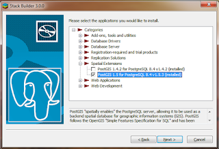
Step1: Install PostGIS with Spatial database support extension

  • If PostgreSQL is already installed è Launch ‘Application stack builder’ from startup menu in windows 7.
  • Select the appropriate instance of PGSQL from dropdown list and Click NEXT.
  • Expand ‘Categories’è Expand ‘Spatial Extensions’ è Select appropriate PostGIS version(1.5)  for the already installed PGSQL version(8.4).
  • Follow the instructions to install the PostGIS extension.


Step2:  Loading spatial data into PostGIS
  • Open the PgAdmin window (above installation should install a ‘Shapefile to PostGIS importer’ plugin.)
  • Select the database and click on ‘Plugins’ and select ‘Shapefiel to PostGIS importer’ plugin.
  • If the plugin is not available under the ‘Plugins’. We can also get it from “C:\Program Files (x86)\PostgreSQL\8.4\bin\postgisgui\shp2pgsql-gui.exe”


  • Select the desired shp file to put into PostGIS.
  • We need to put the appropriate SRID for the imported file. SRID column contains datum information of the imported shapefile into the PostGIS. There are unique SRID for the different projection and datum types.
  •  Above step feeds the spatial information into the database with two additional fields, one for vector geometry id and another for vector geometry with datum information.


Step3:  Retrieving spatial data from PostGIS into Web based applications and Desktop based applications.


  • We can view and project above data using Qgis(An open source GIS alternative to ESRI’s ArcGIS) in desktop based environment. Similarly, we can use Geoserver or UMN Mapserver view data in the Web.
  • The core technologies behind Qgis and GRASS are similar. Qgis is easy to use, support GDAL, Python, PostGIS, and has nice GUI. In the same time we can get strength of GRASS by calling GRASS’s functionality form   the QGIS. 
  • Install Qgis 
  • Open the Qgis --> Click layer--> select ‘Add from PostGIS’, which gives you the following windows.


  •  Click connect, you should able to see the shape layer as below.

  • Finally you will able to see the vector layer in the layer and this layer can be treated as an ordinary shp. file added in the ESRI ArcMap.


jeudi 28 février 2013

AutoCAD WS 1.6.1 Released – AutoCAD Utility Design Now Supported


Description

AutoCAD WS enables you to view, edit, and share AutoCAD® drawings with anyone, anywhere using your mobile device. Annotate and revise drawings in the office, in the field, or in a meeting. Work on designs without an internet connection, and easily open DWG, DWF, and DXF™ files directly from email. Simplify design creation, review, and approval using powerful, built-in social design collaboration tools. Unleash the power of AutoCAD design beyond the desktop with AutoCAD WS.
View
• Open 2D and 3D DWG drawings uploaded to your free* AutoCAD WS online account
• Work offline, then easily upload changes when you are back online
• Upload and open files directly from email on your device
• See all aspects of your DWG file, including external references, layers, and image underlays
• Use multi-touch zoom and pan to easily navigate large drawings
• Use your device’s GPS to orient yourself within a drawing

✓Edit
• Draw and edit shapes with accuracy using Snap
• Select, move, rotate, and scale objects
• Add and edit text annotations directly on your drawing; no need for paper mark-ups
• Validate distance measurements in the drawing while you are onsite
• Save edits to your AutoCAD WS online workspace, so your drawings stay up to date

✓Share
• Share your designs with others directly from the mobile app
• Add comments and images and invite responses using the Design Feed
• Print remotely from your mobile device using HP’s ePrint & Share service
• Plot your designs to PDF or DWF and share them via email


Download :


lundi 25 février 2013

dimanche 24 février 2013

Free E-book: Datums and Map Projections: For Remote Sensing, GI...


Free E-book: Datums and Map Projections: For Remote Sensing, GI...: New methods of acquiring spatial data and the advent of geographic information systems (GIS) for handling and manipulating data mean tha...

Free E-book: Maps and Civilization: Cartography in Culture and ...

Free E-book: Maps and Civilization: Cartography in Culture and ...: In this concise introduction to the history of cartography, Norman J. W. Thrower charts the intimate links between maps and history from ...