Affichage des articles dont le libellé est GIS. Afficher tous les articles

jeudi 23 mai 2013

World Digital Library !


The World Digital Library (WDL) makes available on the Internet, free of charge and in multilingual format, significant primary materials from countries and cultures around the world from 8000 BC to 2009 AD and DOWNLOAD them in TIF and other known formats !

Type of Data/Materials Available :
  • Maps
  • Prints, Photographs
  • Books
  • Manuscripts
  • Motion Pictures
  • Sound Recordings
The principal objectives of the WDL are to:
  • Promote international and intercultural understanding;
  • Expand the volume and variety of cultural content on the Internet;
  • Provide resources for educators, scholars, and general audiences;
  • Build capacity in partner institutions to narrow the digital divide within and between countries.

Easy Drag & Navigable tool to locate the period, identify/select data and download

Topics
History & geography, Earth sciences & geology, Geography & travel, Geology, hydrology & meteorology, Landscape architecture, Historical, geographic & persons treatment, History of Europe, North America, Asia, Middle East & North Africa, Latin America & Caribbean, Africa, Oceania & Pacific, Atlases, maps, charts & plans, Social sciences, Arts & recreation, Religion, Technology, Social groups, Science, Other religions, Social problems & social services, Customs, etiquette & folklore, Agriculture, Architecture, Language, Christianity & Christian theology, Political science, Public administration & military science, Other languages, Plants (Botany), Medicine & health, Landscaping & area planning, Painting, Photography & computer art, Sports, games & entertainment, History of Europe, History of Africa, Creeds & catechisms, Religions of Indic origin, Islam, Babism & Bahai Faith, International relations, General considerations of public administration, Social welfare problems & services, Other social problems & services and many more !

The WDL makes it possible to discover, study, and enjoy cultural treasures from around the world on one site, in a variety of ways. These cultural treasures include, but are not limited to, manuscripts, maps, rare books, musical scores, recordings, films, prints, photographs, and architectural drawings.

Items on the WDL may easily be browsed by place, time, topic, type of item, and contributing institution, or can be located by an open-ended search, in several languages. Special features include interactive geographic clusters, a timeline, advanced image-viewing and interpretive capabilities. Item-level descriptions and interviews with curators about featured items provide additional information.

Navigation tools and content descriptions are provided in Arabic, Chinese, English, French, Portuguese, Russian, and Spanish. Many more languages are represented in the actual books, manuscripts, maps, photographs, and other primary materials, which are provided in their original languages.

The WDL was developed by a team at the U.S. Library of Congress, with contributions by partner institutions in many countries; the support of the United Nations Education, Scientific, and Cultural Organization (UNESCO); and the financial support of a number of companies and private foundations.

jeudi 16 mai 2013

Geospatial Analysis - 4th Edition - de Smith, Goodchild, Longley


  • Title Geospatial Analysis: A Comprehensive Guide to Principles, Techniques and Software Tools
  • Author(s) Michael J de Smith, Michael F Goodchild, Paul A Longley
  • Publisher: Troubador Publishing Ltd; 2nd edition (Dec 19, 2007), eBook, 4th Edition (2013)
  • Hardcover 516 pages
  • eBook HTML 
  • Language: English
Book Description:

This book addresses the full spectrum of analytical techniques that are provided within modern Geographic Information Systems and related geospatial software products. It covers the principal concepts of geospatial analysis and their origins and methodological context.

Includes a chapter on Geocomputational Methods.

Geospatial analysis concepts
Core components of geospatial analysis, including distance and directional analysis, geometrical processing, map algebra, and grid models
Exploratory Spatial Data Analysis (ESDA) and spatial statistics, including spatial autocorrelation and spatial regression
Surface analysis, including surface form analysis, gridding and interpolation methods
Network and locational analysis, including shortest path calculation, travelling salesman problems, facility location and arc routing
Geocomputational methods, including agent-based modelling, artifical neural networks and evolutionary computing


vendredi 15 février 2013

E-book : Studies on Environmental and Applied Geomorphology


Edited by Tommaso Piacentini and Enrico Miccadei


This book includes several geomorphological studies up-to-date, incorporating different disciplines and methodologies, always focused on methods, tools and general issues of environmental and applied geomorphology. In designing the book the integration of multiple methodological fields (geomorphological mapping, remote sensing, meteorological and climate analysis, vegetation and biogeomorphological investigations, geographic information systems GIS, land management methods), study areas, countries and continents (Europe, America, Asia, Africa) are considered.

Click on the link below to start downloading this free ebook:

E-book :Advances in Spatial Planning


Edited by Jaroslav Burian


Spatial planning is a significant part of geosciences that is developing very rapidly. Many new methods and modeling techniques like GIS (Geographical Information Systems), GPS (Global Positioning Systems) or remote sensing techniques have been developed and applied in various aspects of spatial planning. The chapters collected in this book present an excellent profile of the current state of theories, data, analysis methods and modeling techniques used in several case studies. The book is divided into three main parts (Theoretical aspects of spatial planning, Quantitative and computer spatial planning methods and Practical applications of spatial planning) that cover the latest advances in urban, city and spatial planning. The book also shows different aspects of spatial planning and different approaches to case studies in several countries.

Click on the link below to start downloading this free ebook:

Advances in Spatial Planning

E-book : Application of Geographic Information Systems


Edited by Bhuiyan Monwar Alam


The importance of Geographic Information Systems (GIS) can hardly be overemphasized in today’s academic and professional arena. More professionals and academics have been using GIS than ever – urban & regional planners, civil engineers, geographers, spatial economists, sociologists, environmental scientists, criminal justice professionals, political scientists, and alike. As such, it is extremely important to understand the theories and applications of GIS in our teaching, professional work, and research. “The Application of Geographic Information Systems” presents research findings that explain GIS’s applications in different subfields of social sciences. With several case studies conducted in different parts of the world, the book blends together the theories of GIS and their practical implementations in different conditions. It deals with GIS’s application in the broad spectrum of geospatial analysis and modeling, water resources analysis, land use analysis, infrastructure network analysis like transportation and water distribution network, and such. The book is expected to be a useful source of knowledge to the users of GIS who envision its applications in their teaching and research. This easy-to-understand book is surely not the end in itself but a little contribution to toward our understanding of the rich and wonderful subject of GIS.
Click on the link below to start downloading this free ebook:

vendredi 25 janvier 2013

ArcGIS 10.1 Service Pack 1

ArcGIS 10.1

The ArcGIS 10.1 service pack provides you maintenance fixes, performance improvements, software enhancements, and translation updates; all of which will improve the quality of your ArcGIS system.

Please download  after selecting your language and install this required Service Pack at your earliest convenience.

Note: For Non-English Service Packs listed below, there is no need to download and install both English and a language specific Service Pack.

lundi 14 janvier 2013

Geographic Translator : MSP Geotrans 3.2

 MSP Geotrans 3.2

Geotrans 3.2 has been released. Geotrans is the coordinate conversion application or a geographic translator program among a wide variety of coordinate systems, map projections, and datums. Geotrans runs in Microsoft Windows, LINUX and UNIX environments. GEOTRANS can also be used to convert large numbers of coordinates contained in either text files (.txt) or comma separated values (.csv).

To convert a set of coordinates, simply select the coordinate system or map projection, the datum, in which your coordinates are defined, then enter the source coordinates, select the coordinate system or map projection, and the datum, to which you want the coordinates to be converted, and click on the Convert button. The resulting coordinates will be displayed.


 Download :


jeudi 10 janvier 2013

7 Tips for Success as a GIS Consultant

Great article that I want to share and after the permession of the author :

Written by 


This post is an anniversary special. It has officially been one year since I launched my company,Geographic Design. In hindsight, perhaps launching a consulting business straight out of school with no professional network, no real-world industry experience, and no experience whatsoever with the nuts-and-bolts of running a business wasn’t exactly the foolproof endeavor I marketed in my business plan. Fortunately, at the time I had no idea how many things I didn’t know. The learning curve has been steep and it’s been a roller coaster year. Here are some of the things I figured out along the way.

1. The product a GIS consultant sells is not GIS.
The product you are selling is you – your brain, because it is uniquely capable of figuring out the best tools and processes to solve a set of problems, your communication skills to liaise with different departments, and your reputation as an expert in the field. As easy as it is to pitch the capabilities and utility of GIS, that’s not your job, it’s Esri’s. Your job is to sell yourself as a one-of-a-kind opportunity for potential clients. Talk all you like about the wonderful things the technology can do, but make sure what you’re really stressing are the ways that you will contribute to the team and help make the project successful.

2. Forget about knowing “enough” about GIS before you launch your business.
Because you never will. Think of consulting as an ongoing training opportunity. Not only will the technology change, your clients’ demands will evolve to keep up with the digital world, and each project will have unique requirements. You will be paid to do things you’ve never done before, and that’s amazing. Terrifying, but amazing. The mark of a real expert is not that they’ve memorized the manual, but that they are able to figure out anything that comes along without losing their cool. Or at least, that’s my own working definition.

3. If you’re still in school, think carefully before blowing off social events with your peers or irritating your teachers.
Post-secondary is basically a pressure cooker for building close relationships with people who can help you in the business world. Top grades are great ego-boosters, but grades have only ever been a means to an end (such as a scholarship, an internship, an achievement award, admittance to another degree program, etc). Leaving school with a solid network and friendly relationships with successful (and soon-to-be successful) people will last way longer than anyone will remember your GPA.

4. Prepare your introduction.
It’s really off-putting to potential clients/investors/network connections if you can’t articulate clearly what you’re doing and why it matters. When you’re meeting someone new, it doesn’t matter if you have years of experience, boatloads of expertise, or award-winning web mapping skills. It matters that you sound like you have all that and more before you’re finished shaking their hand. You need to be able to deliver an “off-the-cuff” statement describing your business in one or two sentences. Mine is, “I run a small Toronto-based geospatial consultancy. I work with urban designers and planners and support their work with GIS and remote sensing technology.” This is also the beginning of my elevator pitch, which has about another five sentences.
There are no big words that make people’s eyes glaze over. No awkward pauses. No time for their attention to wander or to catch someone else’s eye across the room. I have literally said the exact same thing to probably a hundred people in the past couple of months. Nine times out of ten it leads to my new contact asking for more specific information that, had I offered if immediately, they would never have remembered the next day. I’m not saying it’s perfect – so if you have any suggestions please leave them in the comments.
This doesn’t come naturally to anybody (or at least not to me or anyone I know). No one can take the big picture vision of where they are in their career, where they want to be, and how they plan to get there and distill it into two sentences on the spot. Write it all down. Refine it. Test it out. Refine it again. Memorize it before the next big event/GoGeomatics Meet-up.

5. Be honest.
Part of being a consultant means taking control of the situation. This can be intimidating. I’m often in meetings with brusque senior partners, and sometimes all I want to do is smile and nod at whatever they say. But being candid builds trust, and people want to work with people they trust. As it turns out, partners are people too.
Here are some true things I’ve told clients:
- “I’ve never done this before, but I understand what you’re going for, and I’m sure I can work it out. It might take a little extra time but I’ll work with you closely on this so that next time it comes up, we’ll have the workflow down.”
- “Your GIS data folder is pretty disorganized. Can you budget some time for me up front to get this sorted out properly? It will really help things run smoothly as the project moves forward.” (see here for more on this.)
- “I don’t completely understand what you’re asking for. Could you sketch it for me?”
- I’ve also cut off phone conversations to do a bit of background research. I think it’s reasonable to want to execute a quick web search before answering questions about, for example, what data sets are available for a project in Abu Dhabi.

6. Define your goals. Find time to work on pro bono projects that will get you closer to achieving them.
There are a lot of interesting opportunities out there for someone starting a new venture. Unfortunately, you can justify almost any waste of time as “networking,” “profile building,” or “personal development.” Don’t get me wrong; those are all worthwhile things. And sometimes, by volunteering or working for less than the going rate, you will get back way more than you put in – a new connection, a new client, or a different sort of opportunity. But in the early stages of your business everything you do has to be done with purpose, or for profit, or (ideally) both. It’s not selfish, it’s strategic.
Make sure you’re setting clear goals, and not just financial ones. What kind of work do you want to be doing, and how will each “opportunity” you’re propositioned with move you closer to that? There are, and always will be, lots of chances to volunteer somewhere or team up with someone building the next “sure thing” web trend. Stay on task and don’t get sucked in. My strategy for this is outlined in this flow chart.
GIS Consultant
7. Pay attention to the metrics of success.
As well as defining clear goals, you need to define success. Success is not a trophy, and it doesn’t get presented to you when you’ve made a certain number of maps or hit the top of the Google search results. Success is incremental and quantifiable. Measure it out in the number of repeat clients, the decrease in the ratio of presentations given to contracts awarded, increases in web traffic, and of course, dollars earned. Sometimes success lies in reaching a personal milestone – these successes are extra special and deserve to be celebrated with champagne. Because the point of measuring success (and this is the important part) is celebrating it! Self-employed life is unpredictable, and when you’re working by yourself and for yourself, you could go the rest of your life without ever feeling like you’ve been awarded that trophy. The key is taking the time to throw yourself a party, or dishing out advice on the internet – whatever it takes to mark the occasion.


samedi 29 décembre 2012

Why Use GIS in the Petroleum Industry ?


 The ebook mentioned below  can answer you how GIS technologies are being applied throughout the E&P industry, including in acquisition, seismic planning, exploration, drilling, production, distribution, pipeline, decommisioning, HSE and data management.
Find out how an organisation focussed on the oil and gas sector can benefit from applying intelligent mapping and location analytics technology.
gis petroleum

You can download it for free 

http://www.exprodat.com/Forms/Why-Use-GIS-in-Petroleum.htm

jeudi 27 décembre 2012

Download gvSIG


GVsig

gvSIG is a project dedicate to geomatic science. Download gvSIG free and you will be able to obtain and analyze geographic information in a very precise way

Download gvSIG


mardi 25 décembre 2012

Using the DNR Garmin Extension to Download Waypoints from a GPS Unit


The DNR Garmin is a GPS extension that works with ArcView, ArcMap (8.x, 9.x, 10.x), Landview or ArcExplorer. 
With this extension you can transfer your Garmin GPS waypoints, tracks or routes directly to one of the above programs above and save your data as Graphics or Shapefiles.
In our example we will show how to use DNRgarmin with ArcMap. Before launching the program you should plug your device into the PC.

Plug in the cable in the one of the USB Ports if you are using a “USB” cable or into the “Serial” port if you are using that type of cable.
Please note if you are using Windows XP a “USB” cable might not work properly. Our advice is to use the “Serial” port if you are working on XP.

Step 1

Launch the program by double clicking on the desktop icon.  

Step 1-1:
The program interface will appear like below :

DNR_1


Step1-2:
 The program will try to connect to your GPS device and Check if your device is properly connected to the port and follow the instructions in the message.
Step 2:

Configure your program by clicking on “GPSà Set Portà USB” (if you are using USB cable) or “Port 1” (if you are using Serial).
DNR_2

If your GPS is connected to the program you should see “Connected” in the bottom left corner of the program window.
The program is ready to retrieve your data.
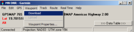
Click on “Waypoint” and then “Download” to download your waypoints into the program.
Or click on “Track” => “Download” if you want to download your Tracks.

DNR_1


After the data is downloaded you will receive a message stating the number of records received.
Step 3:

Click on “>>> Data Table >>>” to see the properties of the downloaded data.
Now you are able to edit your data as needed.
After editing your data, save your data as a shapefile to use it in ArcMap.

DNR_Garmin


Please note: DNRgarmin does not create a projection file (*.prj). You will need to define the projection in ArcCatalog or ArcMap to have a projection associated with your shapefile.

lundi 24 décembre 2012

MapInfo Tools

Mapinfo


Mapinfo Tools  presents an important resources for mapinfo users, you can find a wide range of interesting Utilities and add- ons that help to increase the functionality of MapInfo and make work easier

www.mapinfotools.com


samedi 22 décembre 2012

GADM database of Global Administrative Areas


GADM


GADM is a spatial database of the location of the world's administrative areas (or adminstrative boundaries) for use in GIS and similar software. Administrative areas in this database are countries and lower level subdivisions such as provinces, departments, bibhag, bundeslander, daerah istimewa, fivondronana, krong, landsvæðun, opština, sous-préfectures, counties, and thana. GADM describes where these administrative areas are (the "spatial features"), and for each area it provides some attributes, such as the name and variant names.
The data are available as shapefile, ESRI geodatabase, RData, and Google Earth kmz format. Shapefiles can be used for most mapping and "GIS" software. You can download a free program such as Q-GIS or DIVA-GIS. The RData files can be used in R with the 'sp' package loaded.
You can download the data by country or for the whole  world.


jeudi 20 décembre 2012

ISO/TC 211

ISO/TC211


ISO/TC 211 is a standard technical committee formed within ISO, tasked with covering the areas of digital geographic information (such as used by geographic information systems) and geomatics. It is responsible for preparation of a series of International Standards and Technical Specifications numbered in the range starting at 19101
Scope:

ISO/TC 211 is concerned with the standardization in the field of digital geographic information. This work aims to establish a structured set of standards for information concerning objects or phenomena that are directly or indirectly associated with a location relative to the Earth.
Project specification areas within the ISO/TC 211 technical committee include:
  • Simple Features access
  • Reference models
  • Spatial and temporal schemas
  • Location-based services
  • Metadata
  • Web feature and map services
  • Classification systems
The ISO/TC 211 work is closely related to the efforts of the Open Geospatial Consortium. ISO/TC 211 have numerous liaisons with other organizations that often results in identical or nearly identical standards often being adopted by both organizations.

Georeferencing an image using ArcGIS

Georeferencing involves assigning real-world coordinates to a number of reference points on the image. In ArcMap, this is done using the tools available in ArcMap’s Georeferencing Toolbar. In this example a map is used which has real-world coordinates
labelled near the four corners of the map. These points can be identified and assigned their real-world coordinates. These points are referred to as ‘control points.’
1. Add the image file to ArcMap (by using the 'add data' button just as you normally would - you will be asked if you wish to 'build pyramids,' which you can do to shorten the display time. Building pyramids will result inproduction of *.aux and *.rrd files).
2. Select View/Toolbar/Georeferencing

Georeferencing an image using ArcGIS

3. After selecting control points, zoom into one of them so you can place your mouse as accurately as possible on the point.
4. Under Georeferencing, uncheck “Auto-adjust.”
5. Click on the “Add control points” button.
6. Click on the identified point on the map image and move the mouse somewhere a bit further away. Then click the mouse again. You’ll see a line between a green point and a red point.

Georeferencing an image using ArcGIS


7. The green point is at what’s referred to as the ‘source.’ The red point is at what’s referred to as the ‘target.’ If you wanted to warp the image such that it overlaid with a data layer you had added to ArcMap, the red point would need to be placed at the corresponding point of the existing data layer. However, in this example, you are not warping the image to overlay with a data layer in ArcMap. Rather, you’ll need to provide ArcMap the target coordinate values. To do this, click on the ‘view link table’ button on the Georeferencing toolbar. Change the map x and map y values to reflect the real-world
values read from the map.


Georeferencing an image using ArcGIS

8. Repeat steps 6 and 7 for all of your control points. If you make a mistake, you can a control point by selecting the appropriate row in the table and pressing the “Delete” key on your keyboard. In this example, the final table looks like this:

Georeferencing an image using ArcGIS

9. When you have finished entering control point data, click on OK to close the link table.
10. Select Georeferencing/Rectify. In the next window, change any of the defaults if desired. When the rectification process is finished, you will see that .tif and *.tfw files have been created.
11. Select Georeferencing/Update Display to view your results. Now you should be able to overlay other data (provided those data use the same coordinate system). This example below shows that data for states and major roads overlay with the image.

Georeferencing an image using ArcGIS


mercredi 19 décembre 2012

QGIS Tutorials


Qgis

Intersting tutorial from Harvard :    QGIS Tutorial


  Beginning QGIS Tutorial

PCI GEOMATICS

PCI Geomatics

PCI Geomatics is the developer of Geomatica - a complete and integrated desktop software that features tools for remote sensing, digital photogrammetry, geospatial analysis, map production, mosaicking and Standard image processing capabilities including:

Image enhancements
Filtering
Resampling, reprojection and clipping
Optical satellite image analysis including:
Atmospheric correction
Pixel-based image classification
Contextual/fuzzy classification
Neural network classification
Spectral unmixing
Attribute management tools for analysis with your data including:
Attribute Manager for viewing, editing and querying
Charting
Direct access to more than 100 geospatial data formats through the PCI Geomatics exclusive Generic Database (GDB) technology.
3-D perspective scene generation and fly-through
e.

Download Trial version

Tutorials

Free and Open Source GIS Resources


Bundled Software

Sometimes it's just easier to go one place. Here are some places worth going.

FWTools http://fwtools.maptools.org/

Frank Warmerdam maintains most of the open source infrastructure for handling projections and file formats. It's handy to know what and where they are, since they are often prerequisites for installing other packages: proj4 and GDAL (pronounced "goodle", rhymes with noodle).
FWTools includes pre-compiled binaries for both Windows and Linux of GDAL and proj4, along with the web map server MapServer and raster-oriented desktop OpenEV. Frank contributes to or maintains all these packages.

GIS Knoppix http://www.sourcepole.com/sources/software/gis-knoppix/

GIS Knoppix is a self-booting Linux CD set up to be a sort of Linux workstation on a CD. It has office productivity tools, like OpenOffice , along with a full set of GIS tools: desktop, web map server, etc.

MapServer for Windows (MS4W) http://www.maptools.org/ms4w/index.phtml

MS4W installs pre-compiled windows binaries that comprise a complete development environment for making applications with the MapServer web map server.

Enterprise GIS: Spatially Enabled Databases

PostGIS http://postgis.refractions.net/

PostGIS is the most commonly used back-end database in free software. Most of the desktops listed are PostGIS clients, as well as the MapServer and GeoServer web map servers.

MySQL http://www.mysql.com/

MySQL has spatial extensions , and is supported in both the MapServer and GeoServer web map servers.

Desktops

GRASS http://grass.ibiblio.org/index.html

GRASS , the Geographic Resources Analysis Support System, is a long-standing, complete GIS system. It was originally written in Unix, and runs best in Linux or Unix of some kind. Although the interfaces have recently improved it still has a learning curve. The GRASS community is enormous, and world-wide, with commensurate support resources.

JUMP http://www.jump-project.org/

JUMP supposedly works everywhere, but is much more windows oriented. Has a nice graphical user interface (GUI), and includes conflation tools. It requires SUN's Java Virtual Machine (JVM).

OpenEV http://openev.sourceforge.net/

OpenEV is a raster-oriented viewer with some editing capability. Can display vectors, and create simple shapefiles. Most vector capabilities (snapping, etc.) are not present.

Quantum GIS (QGIS) http://qgis.org/

QGIS is mostly a viewer, with some fairly new editing capabilities. It is more mature on the Linux side of the house, but does have a windows preview release. It is extremely simple to operate, and creates configuration files for the MapServer web map server.

Thuban http://thuban.intevation.org/

Thuban is a viewer, and is definitely cross-platform (Windows, Linux, etc.). It's based on Python.

UDig http://udig.refractions.net/

UDig is still in development, but may suit your needs even in its current form. It's designed to expand on JUMP functionality, and conform to important Open Geospatial Consortium standards. Refractions Research is planning to sell support for uDig.

Web Map Servers

There are quite a variety of these. The two listed below have the most developed capabilities.

MapServer http://mapserver.gis.umn.edu/

MapServer has a very simple set-up and is economical with system resources. It is widely supported and integrated with other packages. The MapServer community has an annual conference.

GeoServer http://geoserver.sourceforge.net/html/index.php

GeoServer is Java-based, and has a fairly complex set-up. It is widely supported, and integrated with other packages.