lundi 31 décembre 2012

Split Layer By Attributes for ArcGIS


split layer by attribute

This is an intresting tool I used a lot to split a layer by attribute .

The tool takes a single shapefile and splits it into many shapefiles based on the unique values of a chosen field

1. Open ArcMap
2. Open Arctoolbox. 
3. Right click on the top level of the Toolbox and you should see a menu come up and one of the choices will be add toolbox. 
4. Navigate to the python directory and add the .tbx file
.

Download :

http://resources.arcgis.com/gallery/file/geoprocessing/details?entryID=37AEB018-1422-2418-A036-CA6D9920F808


samedi 29 décembre 2012

Why Use GIS in the Petroleum Industry ?


 The ebook mentioned below  can answer you how GIS technologies are being applied throughout the E&P industry, including in acquisition, seismic planning, exploration, drilling, production, distribution, pipeline, decommisioning, HSE and data management.
Find out how an organisation focussed on the oil and gas sector can benefit from applying intelligent mapping and location analytics technology.
gis petroleum

You can download it for free 

http://www.exprodat.com/Forms/Why-Use-GIS-in-Petroleum.htm

jeudi 27 décembre 2012

Download gvSIG


GVsig

gvSIG is a project dedicate to geomatic science. Download gvSIG free and you will be able to obtain and analyze geographic information in a very precise way

Download gvSIG


How to upload Geospatial Data from ArcMap to a Garmin GPS


Step 1:
Connect your GPS to your computer with the serial port connector or USB and turn your GPS.

Step 2:
Start DNR Garmin. You should see a box almost or exactly identical to the one below.
DNR

Step 3:
Set the projection needed  (you should only have to do this once) and press OK
- refer to screenshots below:
DNR


Step 4:
Start ArcMap either by itself or from a Toolkit folder that you are working on.


Step 5:
If you want to upload a  shapefile you will need to highlight the layer name that you wish to upload.

Step 6:
After you have the layer selected you need to go back to DNR Garmin (It should already be open)
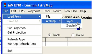
and click on File>Load From>ArcMap>Layer. You can also upload a graphic from ArcMap as well,
you just need to digitize the graphic (point, line or polygon) and select it with your pointer, then
click on graphic instead of layer (in the step displayed below).
DNR
Ajouter une légende
Step 7 :
After you click on Layer, the data will upload and your screen should look something like the screen capture below. By default, points are brought in as waypoints and polygons and lines are brought in as tracks.

DNR
Step 8:
The next step is to click on track (since we loaded a polygon) and the click on upload.

DNR


 Step 9:
You should verify on your GPS that the data has been transferred correctly before you go to the field. To do this you can use the pan map feature on your GPS and zoom into the anticipated location of your data and verify that it has been transferred correctly.


mardi 25 décembre 2012

Using the DNR Garmin Extension to Download Waypoints from a GPS Unit


The DNR Garmin is a GPS extension that works with ArcView, ArcMap (8.x, 9.x, 10.x), Landview or ArcExplorer. 
With this extension you can transfer your Garmin GPS waypoints, tracks or routes directly to one of the above programs above and save your data as Graphics or Shapefiles.
In our example we will show how to use DNRgarmin with ArcMap. Before launching the program you should plug your device into the PC.

Plug in the cable in the one of the USB Ports if you are using a “USB” cable or into the “Serial” port if you are using that type of cable.
Please note if you are using Windows XP a “USB” cable might not work properly. Our advice is to use the “Serial” port if you are working on XP.

Step 1

Launch the program by double clicking on the desktop icon.  

Step 1-1:
The program interface will appear like below :

DNR_1


Step1-2:
 The program will try to connect to your GPS device and Check if your device is properly connected to the port and follow the instructions in the message.
Step 2:

Configure your program by clicking on “GPSà Set Portà USB” (if you are using USB cable) or “Port 1” (if you are using Serial).
DNR_2

If your GPS is connected to the program you should see “Connected” in the bottom left corner of the program window.
The program is ready to retrieve your data.
Click on “Waypoint” and then “Download” to download your waypoints into the program.
Or click on “Track” => “Download” if you want to download your Tracks.

DNR_1


After the data is downloaded you will receive a message stating the number of records received.
Step 3:

Click on “>>> Data Table >>>” to see the properties of the downloaded data.
Now you are able to edit your data as needed.
After editing your data, save your data as a shapefile to use it in ArcMap.

DNR_Garmin


Please note: DNRgarmin does not create a projection file (*.prj). You will need to define the projection in ArcCatalog or ArcMap to have a projection associated with your shapefile.

lundi 24 décembre 2012

MapInfo Tools

Mapinfo


Mapinfo Tools  presents an important resources for mapinfo users, you can find a wide range of interesting Utilities and add- ons that help to increase the functionality of MapInfo and make work easier

www.mapinfotools.com


samedi 22 décembre 2012

GADM database of Global Administrative Areas


GADM


GADM is a spatial database of the location of the world's administrative areas (or adminstrative boundaries) for use in GIS and similar software. Administrative areas in this database are countries and lower level subdivisions such as provinces, departments, bibhag, bundeslander, daerah istimewa, fivondronana, krong, landsvæðun, opština, sous-préfectures, counties, and thana. GADM describes where these administrative areas are (the "spatial features"), and for each area it provides some attributes, such as the name and variant names.
The data are available as shapefile, ESRI geodatabase, RData, and Google Earth kmz format. Shapefiles can be used for most mapping and "GIS" software. You can download a free program such as Q-GIS or DIVA-GIS. The RData files can be used in R with the 'sp' package loaded.
You can download the data by country or for the whole  world.


vendredi 21 décembre 2012

Open Signal Maps.


The Open Signal Maps designed for Androids monitors the signal strength in a network. The application shows the direction and the location of the tower the phone is connected to and also displays the strength of the signal that it is receiving. Network speed can also be easily determined by self run tests on the application.
  

 Users can share the data the app gathers with the OpenSignalMaps website, where the information is processed and visualized on a map.
The website allows users to drill down into the data by network and network type, allowing them to find which network has the best coverage  and  comparisons of download speeds   in any location.

Open Signal Maps


web site  : http://opensignal.com/   
 Download Open Signal Maps          

jeudi 20 décembre 2012

ISO/TC 211

ISO/TC211


ISO/TC 211 is a standard technical committee formed within ISO, tasked with covering the areas of digital geographic information (such as used by geographic information systems) and geomatics. It is responsible for preparation of a series of International Standards and Technical Specifications numbered in the range starting at 19101
Scope:

ISO/TC 211 is concerned with the standardization in the field of digital geographic information. This work aims to establish a structured set of standards for information concerning objects or phenomena that are directly or indirectly associated with a location relative to the Earth.
Project specification areas within the ISO/TC 211 technical committee include:
  • Simple Features access
  • Reference models
  • Spatial and temporal schemas
  • Location-based services
  • Metadata
  • Web feature and map services
  • Classification systems
The ISO/TC 211 work is closely related to the efforts of the Open Geospatial Consortium. ISO/TC 211 have numerous liaisons with other organizations that often results in identical or nearly identical standards often being adopted by both organizations.

ArcBruTile - Tile Services in ArcGIS Desktop

ArcBruTile display maps from OpenStreetMap, Bing, SpatialCloud, MapQuest, Europa Technologies, VR-TheWorld Online, Mapbox, Stamen Design, PDOK and others in ArcGIS Desktop.

Supported maps


Screenshot:

Arcbru Tile

Georeferencing an image using ArcGIS

Georeferencing involves assigning real-world coordinates to a number of reference points on the image. In ArcMap, this is done using the tools available in ArcMap’s Georeferencing Toolbar. In this example a map is used which has real-world coordinates
labelled near the four corners of the map. These points can be identified and assigned their real-world coordinates. These points are referred to as ‘control points.’
1. Add the image file to ArcMap (by using the 'add data' button just as you normally would - you will be asked if you wish to 'build pyramids,' which you can do to shorten the display time. Building pyramids will result inproduction of *.aux and *.rrd files).
2. Select View/Toolbar/Georeferencing

Georeferencing an image using ArcGIS

3. After selecting control points, zoom into one of them so you can place your mouse as accurately as possible on the point.
4. Under Georeferencing, uncheck “Auto-adjust.”
5. Click on the “Add control points” button.
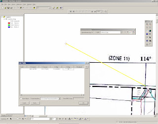
6. Click on the identified point on the map image and move the mouse somewhere a bit further away. Then click the mouse again. You’ll see a line between a green point and a red point.

Georeferencing an image using ArcGIS


7. The green point is at what’s referred to as the ‘source.’ The red point is at what’s referred to as the ‘target.’ If you wanted to warp the image such that it overlaid with a data layer you had added to ArcMap, the red point would need to be placed at the corresponding point of the existing data layer. However, in this example, you are not warping the image to overlay with a data layer in ArcMap. Rather, you’ll need to provide ArcMap the target coordinate values. To do this, click on the ‘view link table’ button on the Georeferencing toolbar. Change the map x and map y values to reflect the real-world
values read from the map.


Georeferencing an image using ArcGIS

8. Repeat steps 6 and 7 for all of your control points. If you make a mistake, you can a control point by selecting the appropriate row in the table and pressing the “Delete” key on your keyboard. In this example, the final table looks like this:

Georeferencing an image using ArcGIS

9. When you have finished entering control point data, click on OK to close the link table.
10. Select Georeferencing/Rectify. In the next window, change any of the defaults if desired. When the rectification process is finished, you will see that .tif and *.tfw files have been created.
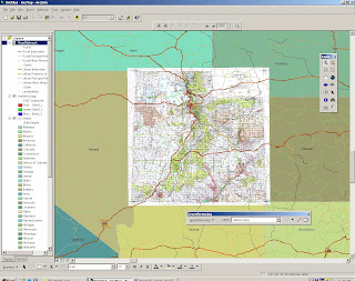
11. Select Georeferencing/Update Display to view your results. Now you should be able to overlay other data (provided those data use the same coordinate system). This example below shows that data for states and major roads overlay with the image.

Georeferencing an image using ArcGIS


Heights Profile with Google Earth

The Heights Profile is very useful to verify the possible obstructions to a link.

To use the Height Profiles, the first thing to do is create a path. For that, one way is to click with mouse right button in the Temporary Places Folder (1) -> Add (2) -> Path (3).


Heights Profile with Google Earth

Then type a name for your path, for example My Link (1). Click the OK button

Heights Profile with Google Earth


Done. Note that the link 'My Link' is now available in the left pane (1). Right click on it and choose Show Elevation Profile (2).


Heights Profile with Google Earth

Voila! There's your Heights Profile (1)! Simpler than you thought, isn't it? :)

Heights Profile with Google Earth


mercredi 19 décembre 2012

Correction d'un Shape file endomagé

Pour corriger  un shape file endommagé, Shapechk  est un utiltaire intéressant qui le  permet, il suffit juste de  le télécharger :  shapechk.exe


La première étape consiste à cliquer sur le bouton  pour sélectionner le fichier de formes endommagé.


L'étape suivante est optionnelle. Il s'agit de cliquer sur le bouton . Ce bouton permet de lire l'en-tête de la donnée mais ne corrige en rien la donnée.

En revanche, le bouton  contrôle le fichier .shx et le génère si cela s'avère nécessaire.


Pour terminer le dernier bouton  contrôle le fichier .dbf. Il permet d'ajouter des lignes à la table attributaire si cela s'avère nécessaire ou d'en supprimer s'il y a des lignes en trop (plus exactement à supprimer les lignes ne correspondant à aucune entité géographique).


Excel To KML


EXCEL TO KML


With the website  Excel to KML you can use a excel spreadsheet
In the spreadsheet you define specific columns and add the necessary data. On the website you can upload the excel file and convert it to KML by viewing it in Google Earth. Then you can download the kml file.

Obtaining shapefiles from OSM data


Open Street Map

This is where you can find extracts of maps from different places around the world. From here you can download:
  • OSM XML extracts by country
  • Garmin Map Files (OSM.err edition)
  • Osmosis country bounding polygon
  • Shapefile extracts by country
  • Navit maps by country
  • GPX POI by country
  • TomTom POI by country
  • OSM XML feature extracts by country
  • Adobe Illustrator files by country
The files provided on these pages are created from OpenStreetMap map data. Because OpenStreetMap is a work in progress many of the countries are only partially mapped or are incomplete. The data contained on these pages has not been checked or verified  and we don't recommend using it for any mission critical applications.

MyGeodata Converter services


MyGeodata Converter

MyGeodata Converter allows you to read and write from/to a huge number of CAD and GIS formats - both vector and raster. MyGeodata Converter is more than only simply data converter! In contrast to common format convertion MyGeodata Converter allows sofisticated data processing during conversion. MyGeodata Converter also can be used as a powerful tool for collective data and attributes processing.

Pack one or more GIS datesets of various formats or coordinate systems to a ZIP file - then you can convert it collectivety to any other format and coordinate system


Run vector Converter                                  Run Raster Converter


Vector                                                                          


List of acceptable input data formatsList of available output data formats
  • ESRI Shapefile
  • Arc/Info Binary Coverage
  • Arc/Info .E00 (ASCII) Coverage
  • Microstation DGN
  • MapInfo File
  • Comma Separated Value (.csv)
  • GML
  • GPX
  • KML
  • GeoJSON
  • UK .NTF
  • SDTS
  • U.S. Census TIGER/Line
  • S-57 (ENC)
  • VRT - Virtual Datasource
  • EPIInfo .REC
  • Atlas BNA
  • Interlis 1
  • Interlis 2
  • GMT
  • X-Plane/Flighgear aeronautical data
  • Geoconcept
  • ESRI Shapefile
  • Microstation DGN
  • MapInfo File
  • Comma Separated Value (.csv)
  • GML
  • GPX
  • KML
  • GeoJSON

Raster :


List of acceptable input data formatsList of available output data formats
  • VRT / Virtual Raster (.vrt)
  • GTiff / GeoTIFF (.tif)
  • NITF / National Imagery Transmission Format (.ntf)
  • RPFTOC / Raster Product Format TOC format (.toc)
  • HFA / Erdas Imagine Images (.img)
  • SAR_CEOS / CEOS SAR Image
  • CEOS / CEOS Image
  • JAXAPALSAR / JAXA PALSAR Product Reader (Level 1.1/1.5)
  • GFF / Ground-based SAR Applications Testbed File Format (.gff)
  • ELAS / ELAS
  • AIG / Arc/Info Binary Grid
  • AAIGrid / Arc/Info ASCII Grid (.asc)
  • SDTS / SDTS Raster (.ddf)
  • OGDI / OGDI Bridge
  • DTED / DTED Elevation Raster
  • PNG / Portable Network Graphics (.png)
  • JPEG / JPEG JFIF (.jpg)
  • MEM / In Memory Raster
  • JDEM / Japanese DEM (.mem)
  • GIF / Graphics Interchange Format (.gif)
  • BIGGIF / Graphics Interchange Format (.gif)
  • ESAT / Envisat Image Format (.n1)
  • BSB / Maptech BSB Nautical Charts
  • XPM / X11 PixMap Format (.xpm)
  • BMP / MS Windows Device Independent Bitmap (.bmp)
  • DIMAP / SPOT DIMAP
  • AirSAR / AirSAR Polarimetric Image
  • RS2 / RadarSat 2 XML Product
  • PCIDSK / PCIDSK Database File (.pix)
  • PCRaster / PCRaster Raster File (.map)
  • ILWIS / ILWIS Raster Map (.mpr/mpl)
  • SGI / SGI Image File Format 1.0 (.rgb)
  • SRTMHGT / SRTMHGT File Format (.hgt)
  • Leveller / Leveller heightfield (.ter)
  • Terragen / Terragen heightfield (.ter)
  • GMT / GMT NetCDF Grid Format (.nc)
  • netCDF / Network Common Data Format (.nc)
  • HDF4 / Hierarchical Data Format Release 4
  • HDF4Image / HDF4 Dataset
  • ISIS3 / USGS Astrogeology ISIS cube (Version 3)
  • ISIS2 / USGS Astrogeology ISIS cube (Version 2)
  • PDS / NASA Planetary Data System
  • ERS / ERMapper .ers Labelled
  • JPEG2000 / JPEG-2000 part 1 (ISO/IEC 15444-1) (.jp2)
  • L1B / NOAA Polar Orbiter Level 1b Data Set
  • FIT / FIT Image
  • GRIB / GRIdded Binary (.grb)
  • RMF / Raster Matrix Format (.rsw)
  • MSGN / EUMETSAT Archive native (.nat)
  • RST / Idrisi Raster A.1 (.rst)
  • INGR / Intergraph Raster
  • GSAG / Golden Software ASCII Grid (.grd)
  • GSBG / Golden Software Binary Grid (.grd)
  • GS7BG / Golden Software 7 Binary Grid (.grd)
  • COSAR / COSAR Annotated Binary Matrix (TerraSAR-X)
  • TSX / TerraSAR-X Product
  • COASP / DRDC COASP SAR Processor Raster (.hdr)
  • PNM / Portable Pixmap Format (netpbm) (.pnm)
  • DOQ1 / USGS DOQ (Old Style)
  • DOQ2 / USGS DOQ (New Style)
  • ENVI / ENVI .hdr Labelled
  • EHdr / ESRI .hdr Labelled
  • GenBin / Generic Binary (.hdr Labelled)
  • PAux / PCI .aux Labelled
  • MFF / Vexcel MFF Raster (.hdr)
  • MFF2 / Vexcel MFF2 (HKV) Raster
  • FujiBAS / Fuji BAS Scanner Image
  • GSC / GSC Geogrid
  • FAST / EOSAT FAST Format
  • BT / VTP .bt (Binary Terrain) 1.3 Format (.bt)
  • LAN / Erdas .LAN/.GIS
  • CPG / Convair PolGASP
  • IDA / Image Data and Analysis
  • NDF / NLAPS Data Format
  • EIR / Erdas Imagine Raw
  • DIPEx / DIPEx
  • LCP / FARSITE v.4 Landscape File (.lcp)
  • RIK / Swedish Grid RIK (.rik)
  • USGSDEM / USGS Optional ASCII DEM (and CDED) (.dem)
  • GXF / GeoSoft Grid Exchange Format (.gxf)
  • HTTP / HTTP Fetching Wrapper
  • HDF5 / Hierarchical Data Format Release 5 (.hdf5)
  • HDF5Image / HDF5 Dataset
  • ADRG / ARC Digitized Raster Graphics (.gen)
  • BLX / Magellan topo (.blx)
  • VRT / Virtual Raster
  • GTiff / GeoTIFF
  • NITF / National Imagery Transmission Format
  • HFA / Erdas Imagine Images (.img)
  • ELAS / ELAS
  • AAIGrid / Arc/Info ASCII Grid
  • DTED / DTED Elevation Raster
  • PNG / Portable Network Graphics
  • JPEG / JPEG JFIF
  • MEM / In Memory Raster
  • GIF / Graphics Interchange Format (.gif)
  • XPM / X11 PixMap Format
  • BMP / MS Windows Device Independent Bitmap
  • PCIDSK / PCIDSK Database File
  • PCRaster / PCRaster Raster File
  • ILWIS / ILWIS Raster Map
  • SGI / SGI Image File Format 1.0
  • SRTMHGT / SRTMHGT File Format
  • Leveller / Leveller heightfield
  • Terragen / Terragen heightfield
  • GMT / GMT NetCDF Grid Format
  • netCDF / Network Common Data Format
  • HDF4Image / HDF4 Dataset
  • ERS / ERMapper .ers Labelled
  • JPEG2000 / JPEG-2000 part 1 (ISO/IEC 15444-1)
  • FIT / FIT Image
  • RMF / Raster Matrix Format
  • RST / Idrisi Raster A.1
  • INGR / Intergraph Raster
  • GSAG / Golden Software ASCII Grid (.grd)
  • GSBG / Golden Software Binary Grid (.grd)
  • PNM / Portable Pixmap Format (netpbm)
  • ENVI / ENVI .hdr Labelled
  • EHdr / ESRI .hdr Labelled
  • PAux / PCI .aux Labelled
  • MFF / Vexcel MFF Raster
  • MFF2 / Vexcel MFF2 (HKV) Raster
  • BT / VTP .bt (Binary Terrain) 1.3 Format
  • IDA / Image Data and Analysis
  • USGSDEM / USGS Optional ASCII DEM (and CDED)
  • BLX / Magellan topo (.blx)
http://converter.mygeodata.eu/


QGIS Tutorials


Qgis

Intersting tutorial from Harvard :    QGIS Tutorial


  Beginning QGIS Tutorial

PCI GEOMATICS

PCI Geomatics

PCI Geomatics is the developer of Geomatica - a complete and integrated desktop software that features tools for remote sensing, digital photogrammetry, geospatial analysis, map production, mosaicking and Standard image processing capabilities including:

Image enhancements
Filtering
Resampling, reprojection and clipping
Optical satellite image analysis including:
Atmospheric correction
Pixel-based image classification
Contextual/fuzzy classification
Neural network classification
Spectral unmixing
Attribute management tools for analysis with your data including:
Attribute Manager for viewing, editing and querying
Charting
Direct access to more than 100 geospatial data formats through the PCI Geomatics exclusive Generic Database (GDB) technology.
3-D perspective scene generation and fly-through
e.

Download Trial version

Tutorials

Free and Open Source GIS Resources


Bundled Software

Sometimes it's just easier to go one place. Here are some places worth going.

FWTools http://fwtools.maptools.org/

Frank Warmerdam maintains most of the open source infrastructure for handling projections and file formats. It's handy to know what and where they are, since they are often prerequisites for installing other packages: proj4 and GDAL (pronounced "goodle", rhymes with noodle).
FWTools includes pre-compiled binaries for both Windows and Linux of GDAL and proj4, along with the web map server MapServer and raster-oriented desktop OpenEV. Frank contributes to or maintains all these packages.

GIS Knoppix http://www.sourcepole.com/sources/software/gis-knoppix/

GIS Knoppix is a self-booting Linux CD set up to be a sort of Linux workstation on a CD. It has office productivity tools, like OpenOffice , along with a full set of GIS tools: desktop, web map server, etc.

MapServer for Windows (MS4W) http://www.maptools.org/ms4w/index.phtml

MS4W installs pre-compiled windows binaries that comprise a complete development environment for making applications with the MapServer web map server.

Enterprise GIS: Spatially Enabled Databases

PostGIS http://postgis.refractions.net/

PostGIS is the most commonly used back-end database in free software. Most of the desktops listed are PostGIS clients, as well as the MapServer and GeoServer web map servers.

MySQL http://www.mysql.com/

MySQL has spatial extensions , and is supported in both the MapServer and GeoServer web map servers.

Desktops

GRASS http://grass.ibiblio.org/index.html

GRASS , the Geographic Resources Analysis Support System, is a long-standing, complete GIS system. It was originally written in Unix, and runs best in Linux or Unix of some kind. Although the interfaces have recently improved it still has a learning curve. The GRASS community is enormous, and world-wide, with commensurate support resources.

JUMP http://www.jump-project.org/

JUMP supposedly works everywhere, but is much more windows oriented. Has a nice graphical user interface (GUI), and includes conflation tools. It requires SUN's Java Virtual Machine (JVM).

OpenEV http://openev.sourceforge.net/

OpenEV is a raster-oriented viewer with some editing capability. Can display vectors, and create simple shapefiles. Most vector capabilities (snapping, etc.) are not present.

Quantum GIS (QGIS) http://qgis.org/

QGIS is mostly a viewer, with some fairly new editing capabilities. It is more mature on the Linux side of the house, but does have a windows preview release. It is extremely simple to operate, and creates configuration files for the MapServer web map server.

Thuban http://thuban.intevation.org/

Thuban is a viewer, and is definitely cross-platform (Windows, Linux, etc.). It's based on Python.

UDig http://udig.refractions.net/

UDig is still in development, but may suit your needs even in its current form. It's designed to expand on JUMP functionality, and conform to important Open Geospatial Consortium standards. Refractions Research is planning to sell support for uDig.

Web Map Servers

There are quite a variety of these. The two listed below have the most developed capabilities.

MapServer http://mapserver.gis.umn.edu/

MapServer has a very simple set-up and is economical with system resources. It is widely supported and integrated with other packages. The MapServer community has an annual conference.

GeoServer http://geoserver.sourceforge.net/html/index.php

GeoServer is Java-based, and has a fairly complex set-up. It is widely supported, and integrated with other packages.