jeudi 27 décembre 2012

Download gvSIG


GVsig

gvSIG is a project dedicate to geomatic science. Download gvSIG free and you will be able to obtain and analyze geographic information in a very precise way

Download gvSIG


How to upload Geospatial Data from ArcMap to a Garmin GPS


Step 1:
Connect your GPS to your computer with the serial port connector or USB and turn your GPS.

Step 2:
Start DNR Garmin. You should see a box almost or exactly identical to the one below.
DNR

Step 3:
Set the projection needed  (you should only have to do this once) and press OK
- refer to screenshots below:
DNR


Step 4:
Start ArcMap either by itself or from a Toolkit folder that you are working on.


Step 5:
If you want to upload a  shapefile you will need to highlight the layer name that you wish to upload.

Step 6:
After you have the layer selected you need to go back to DNR Garmin (It should already be open)
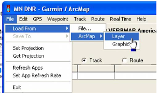
and click on File>Load From>ArcMap>Layer. You can also upload a graphic from ArcMap as well,
you just need to digitize the graphic (point, line or polygon) and select it with your pointer, then
click on graphic instead of layer (in the step displayed below).
DNR
Ajouter une légende
Step 7 :
After you click on Layer, the data will upload and your screen should look something like the screen capture below. By default, points are brought in as waypoints and polygons and lines are brought in as tracks.

DNR
Step 8:
The next step is to click on track (since we loaded a polygon) and the click on upload.

DNR


 Step 9:
You should verify on your GPS that the data has been transferred correctly before you go to the field. To do this you can use the pan map feature on your GPS and zoom into the anticipated location of your data and verify that it has been transferred correctly.


mardi 25 décembre 2012

Using the DNR Garmin Extension to Download Waypoints from a GPS Unit


The DNR Garmin is a GPS extension that works with ArcView, ArcMap (8.x, 9.x, 10.x), Landview or ArcExplorer. 
With this extension you can transfer your Garmin GPS waypoints, tracks or routes directly to one of the above programs above and save your data as Graphics or Shapefiles.
In our example we will show how to use DNRgarmin with ArcMap. Before launching the program you should plug your device into the PC.

Plug in the cable in the one of the USB Ports if you are using a “USB” cable or into the “Serial” port if you are using that type of cable.
Please note if you are using Windows XP a “USB” cable might not work properly. Our advice is to use the “Serial” port if you are working on XP.

Step 1

Launch the program by double clicking on the desktop icon.  

Step 1-1:
The program interface will appear like below :

DNR_1


Step1-2:
 The program will try to connect to your GPS device and Check if your device is properly connected to the port and follow the instructions in the message.
Step 2:

Configure your program by clicking on “GPSà Set Portà USB” (if you are using USB cable) or “Port 1” (if you are using Serial).
DNR_2

If your GPS is connected to the program you should see “Connected” in the bottom left corner of the program window.
The program is ready to retrieve your data.
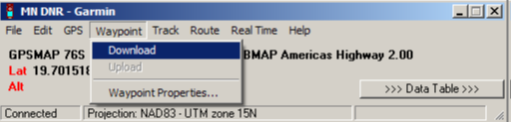
Click on “Waypoint” and then “Download” to download your waypoints into the program.
Or click on “Track” => “Download” if you want to download your Tracks.

DNR_1


After the data is downloaded you will receive a message stating the number of records received.
Step 3:

Click on “>>> Data Table >>>” to see the properties of the downloaded data.
Now you are able to edit your data as needed.
After editing your data, save your data as a shapefile to use it in ArcMap.

DNR_Garmin


Please note: DNRgarmin does not create a projection file (*.prj). You will need to define the projection in ArcCatalog or ArcMap to have a projection associated with your shapefile.

lundi 24 décembre 2012

MapInfo Tools

Mapinfo


Mapinfo Tools  presents an important resources for mapinfo users, you can find a wide range of interesting Utilities and add- ons that help to increase the functionality of MapInfo and make work easier

www.mapinfotools.com


samedi 22 décembre 2012

GADM database of Global Administrative Areas


GADM


GADM is a spatial database of the location of the world's administrative areas (or adminstrative boundaries) for use in GIS and similar software. Administrative areas in this database are countries and lower level subdivisions such as provinces, departments, bibhag, bundeslander, daerah istimewa, fivondronana, krong, landsvæðun, opština, sous-préfectures, counties, and thana. GADM describes where these administrative areas are (the "spatial features"), and for each area it provides some attributes, such as the name and variant names.
The data are available as shapefile, ESRI geodatabase, RData, and Google Earth kmz format. Shapefiles can be used for most mapping and "GIS" software. You can download a free program such as Q-GIS or DIVA-GIS. The RData files can be used in R with the 'sp' package loaded.
You can download the data by country or for the whole  world.